
“Rivers flow not past, but through us.” – John Muir
Floating a river is great recreational fun. Here are 5 great floats that, mid-summer, are suitable for most skill levels and water craft. Three are big rivers, and two are small. They may, depending on flow rate, be a little long for rafts and drift boats, so be sure to check with local sources of information regarding estimating floating times.
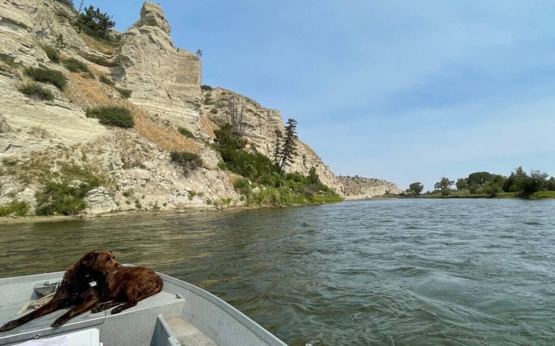
Yellowstone River
The Yellowstone is big, long, wild, and loaded with history. With 550 floatable river miles, there’s a float segment that can meet anyone’s goals and is compatible with most skill levels. One of my favorites is Columbus to Laurel.
A good portion of this stretch, primarily the bottom half, is away from the asphalt and railroad tracks. As a result, it’s quieter, green and fairly pristine. With a natural flood corridor, there are islands and secondary channels.
Put in at Columbus Itch-Kep-Pe Park and take out at either Buffalo Mirage Fishing Access Site (FAS) or Laurel Riverside Park, which are either 23 or 29 miles respectively. There is good camping at Itch-Kep-Pe, Buffalo Mirage and, generally below the high water marks in between.
This is a long stretch, but if you have a good flow rate and a craft you can “motivate” this can be done in a day.
Jefferson River
The Jefferson is relatively small and intimate. In the spring, at high flow, there are lots of sloughs and side channels to explore. Much of the river is not near roads, braids nicely, and has excellent wildlife habitat. As long as the flow rate is above 3000 cfs, any vessel is suitable for Sappington Bridge FAS to Drouillard FAS (15 miles). At higher flows, or with a good paddle craft, you may consider going all the way to Missouri Headwaters State Park (24 miles). There are some small bridges, most are no problem, but the old railroad bridge above “Headwaters” has folded more than a few canoes at high flows.
It’s always been my feeling that the “Jeff” comes the closest to providing an environmental experience akin to what the members of the Lewis and Clark expedition experienced as they followed the course of our Montana rivers. The close proximity of birds and wildlife, dense willows and cottonwoods, and long reaches with no visible buildings contribute to a feeling of wild serenity.
The Jefferson does get dewatered by irrigators in the second half of the summer and may get very low in draught years, so go early (and often).
Missouri River
A lot of people in America know the Missouri River, and it’s the same here in Montana. Up and downstream of Cascade is an easy day trip for beginners with legendary fishing, but for Montanans, so are the crowds. And a multi-day trek down the Wild and Scenic Missouri in central Montana is known for the spectacular “white cliffs” and “breaks.”
To get a taste, consider paddling from Fort Benton (great boat ramps right in town) to Loma (Loma Bridge FAS, 22 miles downstream).
It’s a huge prairie landscape with steep sided grassland bluffs which are incised by coullees and draws that are frequented by mule deer, coyotes, and eagles. The water is fundamentally flat and easy to navigate, but wind is common and is a potential hazard for the unwary. Whitecaps and gusts may threaten stability or impede progress.
This stretch of the Missouri is a fine introduction to the Mighty Mo,’ that just may inspire you to tackle the weeklong trip downstream.
Flathead River
The forks and tributaries of the Flathead River provide numerous options, but for an incredible balance of shoreline picnic sites, scenery, convenience of access, ease of shuttle, and quality habitat it’s hard to beat a float from Teakettle FAS to the Old Steel Bridge FAS (15 miles). And it’s all happening between Columbia Falls and downtown Kalispell.
Multiple channels and backwaters provide a diversity of paddling options and make it a great place to recreate and hone your basic paddling skills. The diversity of channels and abundance of shoreline creates excellent habitat, particularly for birds, but also for floaters.
One note: there is a possibility of increased flow from Hungry Horse Dam located upstream on the South fork. This may significantly change the river flow rate. Typically these will be publicly announced, but be sure to pay attention and check flow rates.
Bitterroot River
The Bitterroot River Valley in western Montana is spectacular, and floating a river is the best way to experience it. To paddle the section from Victor (Bell Crossing FAS) to Florence (Florence Bridge FAS) is a magnificent 15 mile float. Big scenery, a great braided and frequently flooded channel, and proximity to the Lee Metcalf Wildlife Refuge make this particular segment naturally attractive.
While the Valley has development issues, and the river has at times suffered, it is still holding its’ own and, in some cases, has even improved.
This is a smaller, but winding river, so be prepared to backpaddle to contend with possible flood debris and sudden turns.